
Meet the
AgEagle MicaSense Multispectral Series
Setting new standards of excellence for multispectral imaging solutions, the innovative MicaSense Multispectral Payload sensors are the cameras of choice worldwide for advanced applications in agriculture, plant research, land management, and forestry management.
Industry Applications for Multispectral Payloads
Precision Agriculture
Multispectral technology has provided a revolutionary change in agriculture for crop health monitoring and irrigation management. Multispectral imaging empowers farmers to precisely direct their interventions, resulting in amplified yields and enhanced cost-efficiency.
Environmental Management
Multispectral cameras play a pivotal role in monitoring deforestation and examining wetland ecosystems. With the ability to identify shifts in vegetation and soil conditions over extended periods, multispectral data provides valuable information that aids in critical decision-making and implementation of conservation strategies.
Infrastructure Inspection & Monitoring
Building and construction inspections which previously demanded extensive manual labor can now be executed rapidly and securely using multispectral cameras. Drones outfitted with multispectral payloads can reach challenging or hazardous locations that may pose risks to humans and quickly cover extensive distances, allowing for pinpoint accuracy of potential issues or vulnerabilities.
Disaster Management
Multispectral camera-equipped drones are pivotal in disaster management, swiftly evaluating post-natural disaster damage. They provide real-time data to emergency responders, expediting responses and potentially saving lives while accelerating recovery efforts.
Alutm-PT
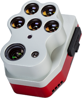
MicaSense Alutm-PT
Engineered with a specific focus on UAV and Vegetation mapping, Altum-PT emerges as an optimized 3-in-1 solution that provides exceptional value for advanced remote sensing and agricultural research.
Stunning Results at Leaf-Level Resolutions
Altum-PT features a high resolution 12.4 MP panchromatic sensor, which allows for “pan-sharpening” of the multispectral imagery, increasing the spatial resolution of the multispectral data – 0.47 inches per pixel pan-sharpened ground resolution when flying at 200 ft.
Thermal Sensor
The built-in 320 x 256 FLIR Boson® thermal sensor enables accurate thermal maps at a GSD of 6.7 inches from 200 ft. flight altitude.
Fast Capture Rate
Altum-PT leverages CFexpress, a 2TB removable storage that enables up to two captures per second, immediate turnaround time between flights by swapping cards, and fast card-to-computer upload speeds for more efficient data management.
Increase Data Accuracy and Repeatability
Each Altum-PT camera kit comes with a Reflectance Panel for on-the-ground calibration as well as a DLS2 light sensor for irradiance and sun angle measurements. These radiometric calibration tools account for different weather and light conditions, providing more accurate, reliable data that enable time series analysis and comparability of outputs over time.
Synchronized Thermal and Multispectral Capture
The simultaneous capture of multispectral, thermal, and panchromatic bands eliminates the need for data alignment in post-processing and enables high-resolution outputs such as RGB color, NDVI, NDRE, CIR.
Five Multispectral Bands
- Blue (475 nm center, 32 nm bandwidth)
- Green (560 nm center, 27 nm bandwidth)
- Red (668 nm center, 14 nm bandwidth)
- Red Edge (717 nm center, 12 nm bandwidth)
- Near-IR (842 nm center, 57 nm bandwidth)
RedEdge-P
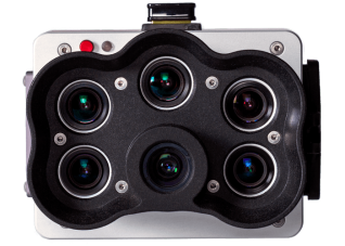
MicaSense RedEdge-P
The RedEdge-P is a rugged, high-quality, powerful multispectral sensor with a high-resolution panchromatic band for pan-sharpened output resolutions. It is a single-camera solution that captures calibrated high-resolution multispectral and RGB imagery with an optimized FOV and capture rate for efficient flights.
Fly Faster and See More
RedEdge-P uses the professional-grade CFexpress memory card standard, providing removable storage with customizable sizes from 64GB to 2TB, allowing constant capture of all image bands every second for over 24 hours. For jobs requiring multiple flights, there’s no need to plug cables into the camera after a flight or bring your computer to the field. RedEdge-P’s removable storage gets your next flight started in seconds.
Season-Long Canopy Analysis at a Higher Resolution
RedEdge-P provides a high-resolution panchromatic band for pan-sharpened output resolutions of 2cm (at 60m) – twice the ground resolution of the industry-standard RedEdge-MX. It enables pixel-aligned outputs at previously unattainable resolutions while maintaining the efficiency and reliability of the RedEdge legacy, opening the door to season-long comprehensive plant canopy analysis at all growth stages.
Calibrated Multispectral Imagery
Each RedEdge-P camera kit comes with a Reflectance Panel for on-the-ground calibration as well as a DLS2 light sensor for irradiance and sun angle measurements. These radiometric calibration tools account for different weather and light conditions, providing more accurate, reliable data that enable time series analysis and comparability of outputs over time.
Powerful AI Capabilities
With its panchromatic band, RedEdge-P enables high-resolution RGB and multispectral imagery for machine learning applications such as plant counting and advanced vegetation research applications.
Synchronized Capture of High-Res RGB and Multispectral
Simultaneous capture of up to six bands allows for multiple high-resolution outputs such as RGB, crop vigor indices, composites (NDVI, NDRE, CIR), and high-resolution panchromatic.
Five Multispectral Bands at 1.6 MP Each
- Blue (475 nm center, 32 nm bandwidth)
- Green (560 nm center, 27 nm bandwidth)
- Red (668 nm center, 14 nm bandwidth)
- Red Edge (717 nm center, 12 nm bandwidth)
- Near-IR (842 nm center, 57 nm bandwidth)