
Meet DJI Terra
Capture, analyze, and visualize your environment with DJI Terra – an easy-to-use mapping software developed to help industry professionals transform real-world scenarios into digital assets.
Capture, analyze and visualize your environment with DJI Terra

Intuitive
& Effortless
Acquire key dimensions across an array of terrains with easy-to-use analysis tools that enable you to obtain a variety of measurement data based on linear, area, and volumetric measurements. Easily edit labels of measurements on existing models, which can be used for reporting and improving communication throughout ongoing projects.
Meet & Exceed
Project Standards
Incorporate POS data, GCPs, or both sets of data to create georeferenced maps and models with enhanced accuracy directly in the target coordinate system required by the project. Convert the coordinates of your maps and models into 8500+ major coordinate systems by simply selecting the output that fits your needs. View a quality report of your mission to ensure the results meet your accuracy standards.
Unparalleled Efficiency & User Experience
DJI Terra features a user-friendly and intuitive interface, ensuring seamless and swift operation from takeoff through landing. Utilizing the power of multiple graphics cards simultaneously, DJI Terra elevates operational efficiency during reconstruction missions by allowing you to leverage resources effectively, expediting the data processing and visualization workflow.

Seamless Area Mapping and 3D Modeling with DJI Terra
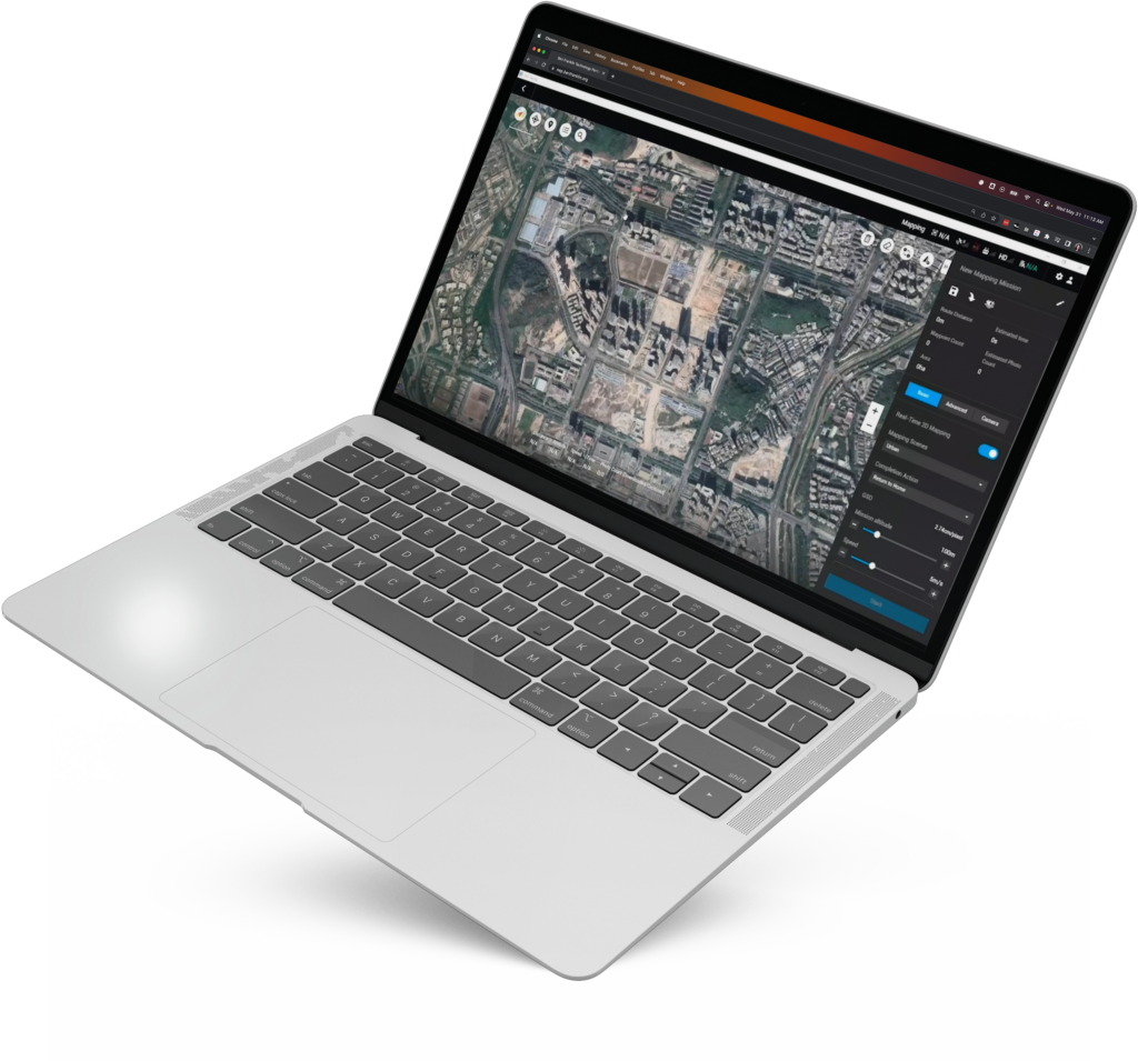
Real-Time 3D Mapping
In situations where efficiency is key, DJI Terra emerges as an indispensable tool, offering the ability to swiftly generate and visualize a comprehensive 3D model of the mapped area. This rapid rendering process saves valuable time and equips decision-makers with essential insights derived from the preliminary model.
3D Models
Realistic 3D models can be generated in three resolutions—high, medium and low. Water surfaces in the model are automatically optimized through AI technology, and formats commonly used within different industries are exported for image reconstruction to recreate diverse scenarios, such as surveying and mapping, accident sites, power grids, and progress-tracking for construction projects.
Real-Time 2D Mapping
DJI Terra can quickly generate a 2D orthomosaic of a selected area in real-time, making it ideal for creating detailed flight paths in remote areas and also for time-sensitive missions that require quick decision-making on-site.
2D Maps
The DJI Terra 2D mapping algorithm is optimized according to different scenarios to significantly improve processing efficiency, effectively avoiding image warping and deformation and obtaining detailed and accurate measurement results for all target objects and survey areas.
Lidar
With just one click, you can perform highly accurate processing of the point cloud data captured by the Zenmuse Lidar in DJI Terra, including route calculation, accurate merging of point cloud and visible light data, optimization of point cloud accuracy, extraction of ground points, and generation of fieldwork reports.
Multispectral
Using multispectral data from DJI Mavic 3 Multispectral and P4 Multispectral, vegetation index maps (including NDVI and NDRE) can be produced using DJI Terra to provide insight into plant growth and health. Prescription maps can be created for variable rate application using DJI’s Agras drones to improve crop yields while driving down costs.
Streamlined Mission Planning
with DJI Terra
Detailed Inspection Mission Planning
Waypoints Mission Planning
Create efficient flight paths using predefined waypoint actions and adjustable parameters like altitude, speed, gimbal pitch angle, aircraft heading and more. For more complex and tight missions that require high attention to detail, use 3D Flight Visualization to design and simulate tasks on existing 3D models.
Area Mission Planning
With just a few taps on the screen, automate complex missions allowing you to seamlessly capture imagery that can be processed to produce a variety of maps and models for further analysis and to aid decision-making.
Oblique Mission Planning
When accuracy is essential and details are critical, Oblique lets you capture data at an angle giving you an extra crisp 3D model of the asset.
Corridor Mission Planning
Create automated flight missions around roads and railways by simply drawing a line on the map. Adjust mission settings to change the total area mapped, giving you the flexibility to choose between creating high-definition 2D maps and 3D models or quick overviews.